What's on the mapWhat's on the mapKey
- A fishing mark
- A mark nearby, tap to see it
RisingHigh water 00:31, in 3 h 48 minNeap tides
Fish activity · more fish, better chance. Tap for why
Good fishing timeDark
Top pick this week
Saturday evening
17:00–19:00
Fish activity · more fish, better chance. Tap for why
Times are the middle of each turn. The small times underneath are slack water, when the level stays close to high or low.
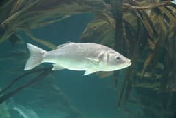
Bass (nearby)Light SSW 9 mph
Not expected here. Expected at Old Aust Ferry Terminal, 4.6 km away, not yet confirmed.
Draft profile, not yet reviewed. Based on FishBase: Dicentrarchus labrax and Cefas, Catchwise: A Survey of Marine Recreational Fishing Activity in England and Wales (2026) and General UK sea-angling guidance (to be verified).
Fish activity · more fish, better chance. Tap for why
Good fishing timeDark
Fish activity · more fish, better chance. Tap for why
Fish activity · more fish, better chance. Tap for why
Fish activity · more fish, better chance. Tap for why
Fish activity · more fish, better chance. Tap for why
Good fishing timeDark
Fish activity · more fish, better chance. Tap for why
Fish activity · more fish, better chance. Tap for why
Our predictions from the Avonmouth Portbury gauge, 7 km away. Heights are above chart datum, as in tide tables. This uses Environment Agency tide gauge data from the real-time data API (Beta). Not for navigation.
Good fishing timeDark
Good fishing timeDark
Good fishing timeDark
Good fishing timeDark
Good fishing timeDark
 A fishing mark
 A mark nearby, tap to see it